Summertime Track

- The Summertime track starts about 10km south of Northcliffe and is 16km north of Windy Harbour. The track is closed from June to October or when unseasonal wet weather strikes (Locked Gate). The track will bring you out at the southern end of the Warren beach. From the southern point of the beach it is about 10km to the Meerup River, then 4.5km to the Calcup Hill exit point. A further 6km will bring you to the Yeagarup Dunes exit. Be aware that there are 2 river crossing to achieve this.
- Contact: DPaW Donnelly District 08) 9776 1207


- Nearest service:Northcliffe / Windy Harbour


- Track Length: 30km
 Windy Harbour
- Distance from Perth: Northcliffe 350 km
Northcliffe to ST01 10 km. - StreetSmart®Travellers Atlas 9th Edition Map: Grid Ref:
- Roads and Tracks Western Australia 2005 Map: Grid Ref:
The water affected 4wd track during winter follows the Doggerup Creek for a couple of kilometers. Even in Febuary the water holes can be up to the running boards. After the swampy environs the track tends to become soft black sand, requiring the lowering of tyre pressures. Best spot to do this is the clearing at the very beginning of the track.


As you approach the coast the track will meander through lightly tree'd, hilly terrain. The final obstacle is a small sand dune (ST04). Depending on the winds this can be easy or interesting. Interesting in the sense that the winds can blow the drift sand onto the track and create a soft peak, with a daunting sideways angle on the other side. If your not sure have a look over the other side first.

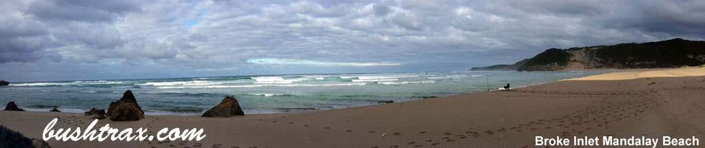
Following the track parallal to the beach brings you to a small creek that feeds in from the hills to the ocean. There is easy access to the beach itself just after you cross the creek. The track does continue further west behind the coastal dunes for abour 5km. There are a few access points to the beach along here also.


Right click mouse and use scroll wheel to zoom the map below. You can also access the free map at maps.bushtrax.com where you view and download the map in the .mbtiles format. We have provided information about some apps that will handle this map format. Using your mobile to view in landscape mode is best.