Peaceful Bay & the Blue Holes

- Peaceful Bay is a small pristine area of the coast with a caravan park & excellent access to the surrounding coastline. The Irwin Inlet is also just down the road. The Blue Holes also known as Bellanger Beach is in the Walpole National Park and offers excellent beach fishing.
- Contact: DPaW Albany 9842 4500


 @ Conspicuous Cliffs
 - Nearest service: Peaceful Bay Caravan Park


 @ Peaceful Bay
 - Track Length: Peaceful Bay 20 km Blue Holes 13 km
 Windy Harbour
- Distance from Perth: Peaceful Bay Caravan Park 446km
- StreetSmart�Travellers Atlas 9th Edition Map: 16 Grid Ref: A 4
- Roads and Tracks Western Australia 2005 Map:1 A Grid Ref: D 2
There are 3 tracks that you can access at Peaceful Bay, these are--> Rame Head rd PB05, The Gap PB23, Soft Beach PB59


The Rame Head track is black sugar sand and has rubber matting spiked into the ground at all the difficult spots. As you descend to the junction at P17, the track is in very good condition and will bring you onto a small beach. From here you will have to travel along the beach until you follow the track over the rocks(PB19) to access the 2nd beach.
The descent on the other side of PB19 may not be suitable for vehicles with low ground clearance. There is a small parking area at the top of the track where the above photo was taken (PB19). It is approximately a 650m walk from here. Driving along the 2nd beach will bring you to the rocks at PB20. Rame Head is about a 350m walk from here.


The Channels can be accessed via a short track from PB18. You can drive all the way round the point to access Salmon Camp beach from here. Taking this route is only practical if prevailing conditions permit this. Salmon Camp beach can be accessed from PB17. The track in is steep with a 180 degree turn at PB22.


The Gap track starts at PB23 and is similar to the Rame Head track. The track will take you to a beach that when conditions allow, you can travel east along the coast and exit via the Soft Beach track. Access to this beach will be greatly affected by the swell and tide.


The Soft Beach track starts at PB59 and as the name implies the beach and track are soft. This track will take you out to Point Irwin where a series of sidetracks will take you to a variety of places. The Gropher Holes is accessed via a sidetrack at PB55. Travelling further along you will find Cape Hope, Kingy Rock, Diamond Rock and Castle Rock. This stretch of coastline is extremely dangerous to fish from the rocks.


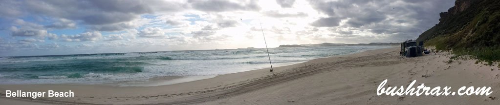
The Blue Holes lies to the east of Nornalup and within the confines of the Walpole/Nornalup National Park. Officially known as Bellanger Beach it is a great beach for fishing.


The approach tracks to the beach are excellent with railway sleepers at the difficult hill climbs. The beach is very soft as is the ascent behind BLU13. The bigger 4wds will find it easier to let your tyres down around BLU10. You can access the Nornalup Inlet mouth from BLU16, though this will depend on beach conditions. The beach does carve out big blue holes which is good for fishing but restricts access to the rest of the beach.


Right click mouse and use scroll wheel to zoom the map below. You can also access the free map at maps.bushtrax.com where you view and download the map in the .mbtiles format. We have provided information about some apps that will handle this map format. Using your mobile to view in landscape mode is best.